Is it worth it?
Thinking about making the walk in person? Here's what you need to know. This is a full day low-level peninsula round trip of 13km which in clear weather will reward you with majestic sea and mountain panoramas, aeons of history and a sense of ancient serenity hard to match anywhere.
Getting there
- Grid Ref: NG390162
- OS Map: Explorer 411 (Cuillin Hills)
- Grade: Easy to moderate
- Distance: Approx 13km (8.5 miles)
- Altitude: Max 69 m. (Profile)
- Time: Allow 4-6 hours
Rubh' an Dùnain is remote. There is no public transport except a once daily return bus between Carbost and Portree during school hours. By road, leave the main A87 at Sligachan and take the A863 signposted Dunvegan. After 8km take the B8009 towards Carbost. Before the village, turn left onto the single-track road signed 'Glen Brittle (7 miles)'. Continue through Glenbrittle House farm and steadings to park at beach before the campsite cattlegrid.
Sensible Precautions
- Skye weather can be highly unpredictable. Check the weather forecast in advance. Pick a clear day.
- Abandon trainers and soft shoes. Wear strong, waterproof walking boots, the ground will be rough and boggy in places.
- Carry warm and waterproof clothing even if the day looks fine. Pack midge repellant.
- It is unlikely there will be any mobile phone signal. Make sure someone knows where you are, or leave a note in your car of the route and anticipated return date and time. Take GPS, camera and binoculars if you have them.
Remember!
The peninsula is active farm land. It also falls within the Cuillin Hills National Scenic Area designated by Scottish National Heritage for its special wildness qualities. There are no access restrictions, but in return it is your responsibility to respect the environment and those whose lives depend on it. Follow the SNH access code. Keep dogs under control at all times. Leave no litter; take only photographs.
Making the Trek
Download before you go:
Waymark Guide for Walkers
These numbers correspond to the waymarks on the accompanying OS Map and Blank Route Card. You can download a printable version of this guide here.
1. Start/end
Glen Brittle beach.(NG410205) Park on the right at the start of the beach and before the entrance to the campsite. If you plan to camp, check out Ukcampsite.co.uk which has up-to-date comments on the facilities. There is a small shop selling basic essentials. The beach itself is grey rather than white sand but it will be clean and there is always some exposed no matter what the tide levels. Rock pools at either end. The more adventurous take a shower below one of the waterfalls which drain the Cuillins into the east side of the sea loch.
2. Loch Brittle
Looking south-west from Glen Brittle beach, the peninsula stretches down the left side of the broad sea loch towards the Rubh' an Dùnain headland itself. Loch Brittle attracts otters, seals, porpoises and the occasional basking shark. Although the beach shelves gradually, beware of offshore winds and an undertow on a strong ebb tide.
Head past the campsite, taking the path to the left of the toilets and strike up as though heading for Coire Lagan. Keep to the broad track and fork right keeping Loch Brittle on your right side. On the horizon, weather permitting, you will see the low, hunched profile of Canna.
3. Allt Coire Lagan
You are in the foothills of some of the most spectacular mountains in the UK. The immense gabbro walls of Sgurr Dearg, Sgurr Mhic Choinnich and Sgurr Alasdair (992m / 3256ft, the highest of the Cuillin range) surround Coire Lagan. Their scale is overpowering. Keep the loch on your right and take the broad track until you reach the Allt Coire Lagan stream. After heavy rain this may be in spate and impassable on foot. There is a wooden bridge a short distance downhill. Return to the track.
4. Cuillin View
Take time to look back and admire the fine view back up Glen Brittle towards Bealach a Mhaim, once the cattle droving track to Sligachan. Before The Clearances in the early part of the 19th century, the Rubh' an Dùnain peninsula, much of Glen Brittle and most of Eynort on the opposite side of the loch were once a single farm under the control of the MacAskill clan. Care is needed fording further streams, one of which has a pretty waterfall.
5. Slochd Dubh
After about an hour's walk, you pass the sea cliffs of Rubha na Creige Moire. Take the path to the left before you reach the small knoll of Creag Mhor. Climb inland until you encounter a stone wall running across the peninsula on a natural fault line. This marks the Slochd Dubh, or Black Ditch. Look for a gap in the wall and cross through keeping Creag Mhor to your right. The track continues parallel to the wall. You should bear right round the shoulder of Creag Mhor until a panorama of the island of Canna and the Small Isles appears ahead and the ground falls away to the headland.
6. Panoramas
The high ground towards Carn Mor to your right is worth a short detour for its expansive views of the settlement, the Small Isles and, on a fine day, all the way to Barra and the Outer Hebrides.
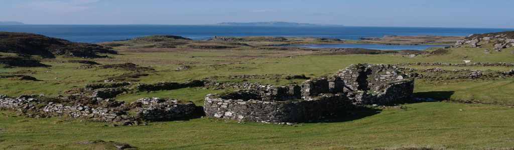
7. Tacksman's House ruins
Continue downhill towards the small loch in the distance. En route you can examine the ruins of the home of the chief of the Clan MacAskill. It was abandoned in the mid-19th century but its ruins still dominate the settlement. Consult the website to see the house in its prime from a sketch by David Roberts c.1840 (image courtesy of Skye and Lochalsh Archive Centre, Portree, High Life Highland). The settlement was gradually abandoned during The Clearances as the crofters left in search of new lives in the US, Canada and New Zealand. In 1863, the land passed out of MacAskill hands after 400 years of occupancy.
8. Iron Age Dun (Fort)
From the house head downhill towards the east end of Loch na h-Airde. Take care to avoid the wet ground to the left. A short detour left brings us to a small iron age rock shelter in which traces of metal smelting were discovered. At the loch's exit to the sea, scramble up the slope to the well-preserved ruins which give Rubh' an Dùnain its name – promontory of the little fort – in Gaelic. With its panoramic view of the western approaches to Skye, the Dun shows a drystone construction, intra-mural gallery, rebated entrance and low scarcement on the inside. It has never been excavated and its full extent was thought to have been much larger. It may have been used to signal to Eigg and Rum. The Sgurr of Eigg is visible 27km to the south. Barra can be seen on a clear day.
9. Stone canal
Mystery continues to surround the archaeology of the channel below the fort. A boat timber dated to 1100AD was recovered from the loch in 2000, and several on-going studies have identified underwater wharves and evidence of nausts or boathouse docks. Experts say it is “ truly a multi-period and multi-functional site, for which the sea is the linking strand.” There is strong evidence of a Viking presence but whether they actually constructed the canal – unique in Scotland and displaying sophisticated stonemasonry – to service an early medieval shipyard, is not yet certain. And who made the mechanism to maintain water levels in the loch? One thing is clear, Loch na h-Airde has more secrets still to reveal.
10. Abandoned Croft Ruins
Head due west towards the very tip of the peninsula. The ruins of the settlement lie scattered below the loch with the striking backdrop of the Cuillin ridge. By the end of the 18th century, the headland was part of a substantial MacAskill farm covering much of Eynort and Glenbrittle, part of the Cuillins up to Allt Dearg and including the island of Soay. The promontory itself was extensively farmed and supported more than 100 tenants. When the last clan chief left the peninsula in 1853, the farm totalled 37,500 acres and supported 70 men.
11. Loch Viewpoint
Stop at the western edge of the headland for a last lingering look towards the Iron Age fort. It is not difficult to see why early settlers chose the location for a defensive structure. The fort has a 270 deg view of the coast. With the naked eye you can see the length of the Sound of Soay, the 7-mile expanse to Canna and and the wider reaches of the Inner Hebrides as well as anything heading south from Loch Eynort and beyond. The fort also represents a 'see and be seen' approach, serving as a warning as well as a look-out and also acts as a marker for entering the Loch na h-Airde harbour and sanctuary.
12. View from the sea
Take time to pause on the very tip of the peninsula and consider the view from the sea. The website shows a picture of Rubh' an Dùnain taken from sea kayak and clearly illustrates how easy it would have been to conceal boats in the loch and slipways from passing vessels. The entrance is hidden until very close to the shore.
13. Chambered Cairn
Walking now towards the north shore of the loch takes you to the chambered cairn. It is a fine open example of a bronze age, neolithic passage tomb (2400 BC to 551 BC) first explored in 1932. It has yielded a beaker, flint scrapers and pottery shards. Although much of the cairn's original contents were likely long plundered and with them any human remains, the stonework and the skill and precision of the construction, is impressive. Renewed interest in the cairn and further scientific study may yet reveal more information.
14. Canna sunset
It is time to turn for home. Head north round the western edge of Carn Mor to pick up the original track. The shoreline is dangerous – so keep well above it. The main picture shows a fishing boat making its way homeward towards Skye from Canna on a summer's evening. You can listen out for the thrumming wings of a snipe as twilight falls. High-summer nights on the island rarely bring complete darkness.
15. Homeward bound
Follow the headland above the sea cliffs where there is a faint path along a shelf between the sea and Creag Mhor to eventually rejoin the main track. Retrace your steps back to Glen Brittle beach.
Guided Walks
Highland Council's Countryside Ranger Service offers occasional guided walks to the peninsula. Contact the Skye and Lochalsh office at 01471 820526 or via their website. John Phillips, the recently-retired senior countryside ranger for Skye and Lochalsh is hugely knowledgeable about Rubh' an Dùnain and deeply interested in its history. He can be contacted through Wild About Skye.
